Weather and the Atmosphere Site Map

(S-1A)   Weather and the Atmosphere

    An optional extension of section (S-1) "Sunlight and the Earth." A more detailed (but qualitative) discussion of heat flow in the atmosphere and related weather processes, including the roles of buoyancy, convection and humidity.

    Around and around goes the wind,
    and from its circuits returns the wind.

                    Ecclesiastes, ch. 1, v.6

Pressure and Convection

    Let us start with the flow of air. Suppose a "parcel of air" (that's the term you see) is heated near the ground by conduction of heat, the flow of heat due to direct contact with the warm surface. Heat makes it expand, it becomes less dense than the surrounding air and buoyant, and it rises like a hot-air balloon (or like a drop of oil in a bottle of water).

    At the higher levels of the atmosphere, this warm bubble again gives up its heat (to other flows or perhaps to cold space), cools down, and other bubbles coming from below push it to the side, where it descends again. (diagram on the board). Such a circulating flow is called convection.

More generally, convection is any flow which

  1. picks up heat at one place,
  2. drops it at another, and
  3. is driven by this transport of heat.

The important thing to remember when dealing with convective flows, is that the higher one is in the atmosphere, the lower are the pressure and density of the air. What compresses it is the weight of air above it which it must support. On top of Mt. Everest, less air is piled up on top and therefore the pressure is lower.

At ground level, the compressing weight of the atmosphere amounts to about 1 kilogram on each square centimeter. That pressure does not bother our bodies, because the air inside us is at the same pressure, and the fluids of the body (like blood) do not compress easily. For the same reason, fish have no problems with depth--even at a depth of 100 meters, with a pressure 11 times larger (10 kilogram water above each square centimeter, plus the weight of the atmosphere) they feel no discomfort.

    (Divers too can stand such pressure, provided the air they breathe is similarly compressed--except that the mixture must be changed, otherwise they may take in too much oxygen, and too much nitrogen is dissolved in their bloodstream.)

At an altitude of about 5 kilometers, only half the atmosphere is above us, the other half is below, so only the weight of half the atmosphere must be supported, and the pressure is reduced to one half.

By "Boyle's law" (named for Robert Boyle, 1627-91), the density is also reduced to one half (ignoring any variation in temperature). Rising an additional 5 kilometers, the pressure again falls by half, to 1/4 of what it was on the ground, and at 15 kilometers, it is halved again to about 1/8. All this is approximate and depends on temperature, but the trend should be clear.

The cabin of a jetliner flying at 10 km must be sealed and pressurized, because passengers breathing air at 1/4 the sea-level density would be starved for oxygen and might lose consciousness. On the very rare occasions when a jetliner loses its pressure, masks connected to oxygen canisters drop down automatically, allowing the passengers to breathe normally while the pilot quickly descends to a lower altitude.


The Higher We Go, the Cooler it Gets--Why??

When the atmosphere is stable, the higher we go, the cooler the air is.

Air is warmest near the ground, which absorbs receives heat from sunlight. It is coldest above the level where jetliners fly, at 10-15 kilometers, the region from where it radiates most of its heat into space. That is why mountaintops are cold and the highest mountains have snow on their tops.

    (Still higher layers may get quite hot again, by absorbing UV and "extreme UV," but they have little effect on what goes on below them).

How exactly does this happen?

Suppose some "parcel of air" (dry air, for now--humidity is an additional factor, considered later) is heated by the ground and rises. Higher up the pressure is lower, so the air expands: but expansion cools it.

Similarly, if for some reason the parcel is blown down, is is compressed again and heated by the compression. Such up-and-down motions happen all the time, and the net result is that when conditions are stable, the temperature drops at a steady rate as we go higher.

The motion of the rising parcel of air depends on its surroundings. It always cools by expansion--but is it still warmer than the still air around it? If it is, it continues to rise; if not, it stops. As will be seen, this is where the humidity of air has an important effect.

    [ On an ordinary day, direct heating by the ground only carries the air a few hundred meters, perhaps a kilometer, creating above the ground a "boundary layer" with many small convective flows. Large scale motions like thunderstorms usually occur higher up (see below).]

Global Weather

    Global flows in the atmosphere follow the basic principles of convection:


    --All air motions are powered by the heat of the Sun.
    --Air motions try to get rid of this heat as efficiently as possible.
    --In general, heated air flows away from where it is heated
            to where it can best send its heat back to space.


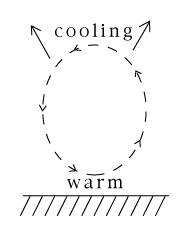
    Heat is absorbed (mostly) by the ground. Furthermore, heating is most intense near the equator, where the Sun's rays come down most steeply. Slanting rays spread their heating over a wide area, but steep rays don't.

    Heat is lost from Earth by being radiated back to space, as infra-red light. Anything warm or hot emits radiation--visible light for very hot objects (such as the Sun), infra-red light for moderately warm ones--but warm or hot, they shine away heat. That can happen almost equally well anywhere on Earth.

    So... spreading out the heat arriving near the equator helps return it to space, allowing the entire atmosphere to participate in its return. This yields a more efficient disposal of heat, and that is what global atmospheric flows try to achieve. We say "flow of heat" but what actually flows (as in any convection) is air -- warm air towards the poles, cooled air towards the equator.

    As such flows take place, the rotation of the Earth enters the picture (this was discussed in section #24, but is repeated here). Air at the equator, rotating with the Earth, moves eastward at more than 400 m/sec. As air flows poleward, it gets closer to the Earth axis, to where the surface moves more slowly (the rotation velocity drops to zero at the pole). Because of its inertia, the flowing air retains at least some of its greater speed and overtakes the rotation of the Earth. Thus motion which started by heading polewards gradually slants eastwards (drawing below--right-hand flow). How poleward and equatorward flows on the rotating Earth become curved

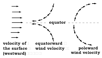
    Ultimately that air cools down, and perhaps it also loses its extra eastward velocity (all or some of it) to friction with the ground. Now it must return to the equator, pushed out by some other mass of air, newly arrived from equatorial latitudes. As it approaches the equator, the ground below it is moving eastward faster, so that by inertia, the returning air lags behind it. If it started flowing directly equatorward, this lagging causes its flow to slant westward (drawing above--left-hand flow).

    The result is similar to the one found in section #24, in discussing the Coriolis effect. North of the equator, both drawn sections tend to circulate clockwise; south of the equator the circulation is counterclockwise. A series of circulating flows between the equator and northern middle latitudes

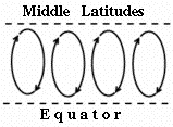
    As the bible already stated (quote at the beginning of this section), every flow in the atmosphere is a closed circulation. So as a very simplified picture, one can visualize the flow north of the equator as a series of clockwise loops:

    But there is more to the global picture.

    The Earth is round, and on a global scale, all these motions transfer momentum. They transfer eastward momentum from the equator to middle latitudes, and since momentum is conserved (Newton's 3rd law--"every action has an equal and opposite reaction") an equal westward momentum is transferred to the equatorial region.

    The overall effect is an eastward flow of air (winds blowing from the west or "westerlies") at middle latitudes, and a westward flow of air ("easterlies" blowing from the east) in the equatorial region

    The westerlies dominate weather in the 48 states of the continental USA and in Europe. Winds may blow from the northwest or southwest, reflecting waves in the flow due to the circulations drawn above, but generally they come from "somewhere in the west." The fastest flow in this great stream (as in any river) is in its middle, and there the air flows fastest at high altitudes, say 30,000. That fast core flow is known as the jetstream, well known from weather maps--providing welcome tailwinds for airliners heading eastwards and being avoided (as much as possible) by westbound flights. Weather forecasters like to show the jetstream, because its location marks the general position of the much larger eastward flow. And its often show a wavelike shape.

    In the age of sailing ships, sea-captains took advantage of this system. Sailing from Spain to America, they would go closer to the equator, a more southern route that took advantage of the easterly "trade winds." Sailing back home they would venture further north and use the westerlies. The many Spanish wrecks off Florida, some with quite rich cargo, were lost to storms on this home voyage back to Spain. Those ships were loaded with gold and silver from Mexico and South America, and followed the coast of Florida northward before turning westward towards Europe.

    Postscript:     Clockwise loops north of the equator? Don't hurricanes rotate the opposite way? They indeed do. However, hurricanes are associated with hot humid water getting rid of its humidity in the form of rain, a somewhat different process.

.

Water vapor

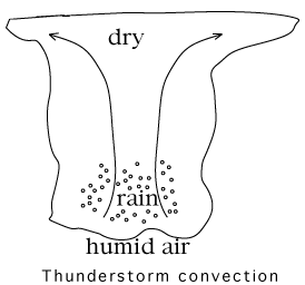
   Instead of heating the Earth, sunlight can evaporate water from it--especially from the oceans, which cover most of the Earth's surface. Humid air may be viewed as containing additional energy, invested by the Sun when its heat evaporated the water. While heat drives convection, humidity may amplify it.

   Hot humid air is what drives thunderstorms, and a warm ocean surface is also the traditional birthplace of violent tropical storms, known as hurricanes in America and typhoons in Asia.

We look at two examples of humidity in action.

  1. In a thunderstorm, hot humid air rises, as in ordinary convection. As it rises to regions of lower pressure, it cools by expanding. However, cold air cannot hold as much humidity as warm air, and the extra water is therefore squeezed out. In moderate convection it forms clouds (as in the second example below), but in a vigorous thunderstorm, there is too much of it and it turns into rain.

       Giving up water heats the air, or rather, slows down its cooling, because the heat invested by the Sun in evaporating the water is now passed back to the air. As a result, the rising air is still warmer than the air layers around it, and it continues to rise vigorously. It squeezes out still more rain and forms the tall thunderstorm clouds, which pilots know well to avoid.

          (In very vigorous thunderstorms, the "updrafts" of rising air may rise so quickly that they blow raindrops into the higher and colder sections of the cloud, where they freeze, producing hail. Some hailstones are picked up again and again, adding layers of ice on each upwards journey. That is how unusually big hailstones can form.)

  2.    On a hot clear day, many fluffy small clouds may form. A light plane flies across the land, and every time it comes under a cloud, the pilot feels that it is bodily lifted. What is happening?

       --Here is the reason. The heating of the ground by the Sun has created many small convection currents rising upwards. Their air contains humidity, not enough for a serious thunderstorm, but enough to produce small clouds when droplets of water condense as the rising air cools.

        The small clouds mark the top of the "boundary layer" near the ground, with many small circulating flows. Each cloud sits on top of a rising convection current, which lifts the airplane as it flies across it. Since "what goes up must come down" the pilot can also expect downdrafts between the clouds, where the air goes down again, as part of the circulating convection. Such up-and-down motions may make passengers on low-flying airplanes quite airsick!

Further Exploring

Strictly for those interested in history: the original 1896 article in which Svante Arrhenius proposed the greenhouse effect. Note that carbon dioxide was then called "carbonic acid."


Tidbit:

   Who first wrote "Everybody talks about the weather, but nobody does anything about it"? Most would claim it was Mark Twain (just type the first 5 words into a search engine and see!), but it ain't necessarily so. It reads like Twain's style, but actually the words first appeared in an editorial in the Hartford (Conn.) Courant on 24 August 1897, written by Charles Dudley Warner.

    Warner was a good friend of Twain, who himself had lived in Hartford for many years (he left before 1897). He was a newspaperman in Hartford and the two had collaborated on an 1873 book "The Gilded Age." Warner is also remembered for other quotes, e.g. "Politics make strange bedfellows."

Concerning the quote, see on the web
        http://www.m-w.com/wftw/99aug/082499.htm.
and more about Charles Dudley Warner (and Twain) at
        http://courant.ctnow.com/projects/twain/warner.htm.


Next Stop:
(S-2) Our View of the Sun

            Timeline                     Glossary                     Back to the Master List

Author and Curator:   Dr. David P. Stern
     Mail to Dr.Stern:   audavstern("at" symbol)erols.com .

Last updated: 11.24.2002