Site Map
Lesson plan
Glossary
Timeline
Questions & Answers
Central Home Page


(S-1B)   Global Climate, Global Wind Flow

    Index

24b. Rotating Frames

The Sun

S-1. Sunlight & Earth

S-1A. Weather

S-1B. Global Climate

S-2.Solar Layers

S-3.The Magnetic Sun

S-3A. Interplanetary
        Magnetic Fields

S-4. Colors of Sunlight

S-4A.Color Expts.

S-5.Waves & Photons

Optional: Quantum Physics

Q1.Quantum Physics

Q2. Atoms

Q3. Energy Levels

Q4. Radiation from
        Hot Objects

Q5.The Atomic Nucleus
        and Bohr's Model

Q6. Expansion of
        Bohr's Model

Climate and Latitude

    The distribution of the Sun's heat over surface of Earth Sun's heat is quite uneven. Heating is most intense near the equator, where the Sun's rays come down steeply. Such sunlight, arriving at a steep angle, heats the ground much more effectively than light that slants, whose heating is spread out over a wider area (see "The angle of the Sun's rays").

    Most of climate is dictated by the way that heating is distributed. It also depends on the tilt of the Earth's axis which gives us the seasons, and by the distribution of oceans, which store the Sun's heat and moderate the climate. Regions far from the ocean experience greater extremes of hot and cold weather, and may also be drier.

    The warm tropical regions are traditionally the ones between latitudes 23.5° north and south, lines of latitude known as the "tropic of cancer" and the "tropic of capricorn." Anywhere in that region, which straddles the equator, at least one day exists in the year when the noontime Sun is directly overhead. And the polar regions are the regions poleward of the arctic circles (latitude 66.5°) where at least on one day in winter, the center of the Sun is below the horizon all day long. Those are the regions experiencing "polar night" in midwinter, and hardly any plants survive there. In mid-summer, polar days get very long, but with the Sun close to the horizon, its rays arrive at a shallow angle and their heating power is minimal.

    The Sun's energy input is what drives climate, but the atmosphere also has an important role. Heat given to the ground does not stay where it is deposited. Sooner or later the warm ground radiates it away in the form of infra-red light. Those infra-red rays, in turn, do not travel far before being re-absorbed by greenhouse gases such as water vapor (see S-1 Sunlight and the Earth). Later those gas molecules again give up their heat, also as infra-red radiation, some of which reaches further upwards. By such a chain of absorption and re-emission heat gradually spreads, like sunlight in a fog, until some of it reaches rarefied levels from where it can be radiated to space, never to return.

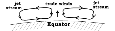
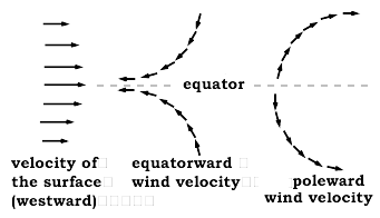
    The level where this happens is the beginning of a dry and stable atmospheric layer known as the stratosphere. The part of the atmosphere below that-- the region where weather takes place, more active and more humid--is called the troposphere, and the boundary between it and the stratosphere is the tropopause

Large-scale air flows near the equator

    As heat diffuses through the layers of the atmosphere, it is also spread by atmospheric flows, by winds. In general


    --All air flows are powered by the heat energy
                    given to the ground by the Sun.

    --Air flows try to get rid of this heat as efficiently as possible.
    --In general, heated air flows away from where it is heated
                    to where it can best send its heat back to space.


    Most heat arrives in the tropics, but it can be re-radiated from the top of the atmosphere anywhere on Earth. Spreading it out allows a larger area of the atmosphere to participate in its return. This yields a more efficient disposal of heat, and that is what global atmospheric flows try to achieve. Warm air is transported towards the poles, cooled air returns equatorward.

    Currently Earth experiences a growth in the "greenhouse effect"--the effect of gases like CO2 (carbon dioxide), methane, water vapor and ozone, which impedes the flow of heat from the ground where it is first absorbed, to the top of the atmosphere where it is radiated back to space.

    Global flows, described below, help drive heated air from the equator towards the poles, spreading the area of heat return. When the transport of heat from the ground to the top layers is impeded by the "greenhouse effect," such flows may be driven to spread the area participating in heat return, making them extend further poleward. The result of such spreading could be the recently observed melting of polar sea ice (which threatens polar bears) and of glaciers in Greenland and in Antarctica.

But how does this happen?

    The answer is complicated (and I thank Dr. Mark Schoeberl of NASA's Goddard Space Flight Center for helping me out). First of all, since the atmosphere is 3 dimensional one may well ask--are the dominant motions vertical or horizontal? Logic alone is an uncertain guide. It is much better to observe how nature does it, or (in recent years) use large computers to simulate the physics, reassuring us that the factors we hold responsible indeed combine to act this way.

Hadley cell circulation

    It was Hadley in 1735 who proposed the motion was mainly vertical (see drawing above). If the Earth did not rotate, such a flow would be confined to a north-south plane. Hot air would rise near the equator and cool down at higher altitudes, while cooler air from off-equator regions would flow equatorward and take its place.

    The rotation of the Earth greatly modifies this flow, by the Coriolis effect, as will now be explained. Look first at the right side of the drawing below.

  • Air at the equator moves with the ground below, so its east-west motion matches that of the equator.

  •    Away from the equator, however, the Earth's surface comes closer to the rotation axis. Therefore, the distance any point on the surface covers in 24 hours becomes smaller, and its west-to-east speed gets slower. If the air moving away from the equator persists at its original west-to-east speed, it will overtake the local surface, making the predominant winds blow from west to east. The arrows on the right-hand drawing then show its velocity relative to the ground. The result are the "westerlies", a persistent ring of winds from the west.

  •     The westerlies dominate weather in the 48 states of the continental USA and in Europe. Winds may blow from the northwest or southwest, reflecting waves in the flow (discussed later), but generally they come from "somewhere in the west." The fastest flow in this great stream (as in any river) is in its middle, and there the air flows fastest at high altitudes, say at 30,000 ft (10 km). That fast core flow is known as the jetstream, well known from weather maps--providing welcome tailwinds for airliners heading eastwards and being avoided (as much as possible) by westbound flights. Weather forecasters like to show the jetstream, because its location marks the general position of the much larger eastward flow.

  •     The cooler air returns equatorward (towards the middle of the drawing of the Hadley flow) at lower altitudes, completing the loop. If that air still kept its original west-to-east speed, it would again match the local rotation of the equator.

  •     However, on a global scale, all these motions transfer momentum. They transfer eastward momentum from the equator to middle latitudes, and since momentum is conserved (Newton's 3rd law--"every action has an equal and opposite reaction") an equal westward momentum must be transferred to the equatorial region. The overall effect is an eastward flow of air (winds blowing from the west or "westerlies") at middle latitudes, and a westward flow of air ("easterlies" blowing from the east) in the equatorial region    

        In the age of sailing ships, sea-captains took advantage of this system. Sailing from Spain to America, they would go closer to the equator, a more southern route that took advantage of the "trade winds." blowing from the east. Sailing back home they would go further north and use the westerlies. The many Spanish wrecks off Florida, some containing quite rich cargo, were lost on this home voyage back to Spain, loaded with gold and silver from Mexico and South America.

    Large-scale air flows further poleward

        Observations confirm that convective "Hadley cells" actually exist near the equator, but they only extend to a latitudes of about 20°. That is where the Hadley flow descends again. The upward flow of the Hadley cells can raise the tropopause up to 16 kilometers (10 miles). Where the flow descends, the tropopause moves down too, and can be as low as 10 km. The descending air is also dry, and that causes a belt of deserts at these latitudes--in the southwest US and in Mexico, the Sahara, Arabia, Namibia and the interior of Australia.

        Another effect is the varying thickness of the ozone layer, the stratospheric gas which protects us from the Sun's ultra-violet emissions. Over the equator the stratosphere is pushed upwards, where it lasts longer, while in middle latitudes ozone flows to lower levels, where it lasts longer. As a result, ultra-violet intensity is greater in equatorial latitudes. This may be why residents of those regions have developed darker skin, which helps protect them against the ultra-violet.

    Rossby waves in west-to-east air flow

        The Sun still causes a lot of heating poleward of 20°--e.g. in Florida and Hawaii--but the air flows which spread it are not vertical but horizontal. They are caused by instabilities in the flow of the westerlies, of a sort which spreads heat further poleward. What happens is that the main flow from the west develops "Rossby waves" which extend it further poleward. Inside the poleward loops of those waves, higher pressure develops, while inside the return loops, pressure is lower (see illustration). As air flows in and out of those regions of different pressure, it swirls around (see Rotating frames of reference in space and on Earth), and this too helps spread warm air poleward. It must be stressed that global flows are rarely as "clean" as they appear in the above image, usually they also exhibit an appreciable degree of "disorder".

        As those who watch weather forecasts know, those waves can shift appreciably. That is what makes US weather so variable and hard to predict: it only takes a slight shift to send your expected rainfall into a neighboring state (or the other way around). Ground structure also affect the flow, e.g. the mountain belt of the western US tends to shift the westerlies in their sector poleward, towards Canada.

        Because of the uneven distribution of land and ocean, of plains and mountains, the preceding pattern may also be modified in other ways. In particular, a pattern above the equatorial Pacific Ocean flows not just in the north-south direction but also between east and west. Shifts in that pattern cause a global weather modification known as El Niño--"The Child" in Spanish, meaning the Christmas child, a name given by Peruvian fishermen because (when it occurs) its onset is pronounced around December. It is associated with warmer surface water in the Pacific Ocean.


    Questions from Users:
            ***      
    Tracking of radioactivity carried by winds
                     ***       Imagine a non-rotating Earth
                           ***       Counter-clockwise swirling motion in the atmosphere
                                 ***       Evidence for Global Warming ?

  • Next Stop: (S-2) Our View of the Sun

                Timeline                     Glossary                     Back to the Master List

    Author and Curator:   Dr. David P. Stern
         Mail to Dr.Stern:   stargaze("at" symbol)phy6.org .

    Updated 18 March 2012  ;  Edited 16 October 2016